Barkot night lights from space
Night Light of Barkot (Uttarakhand) from space (India) Src. Average luminocity for 10x10km area is 6.007% and for 50x50km: 1.5019%.
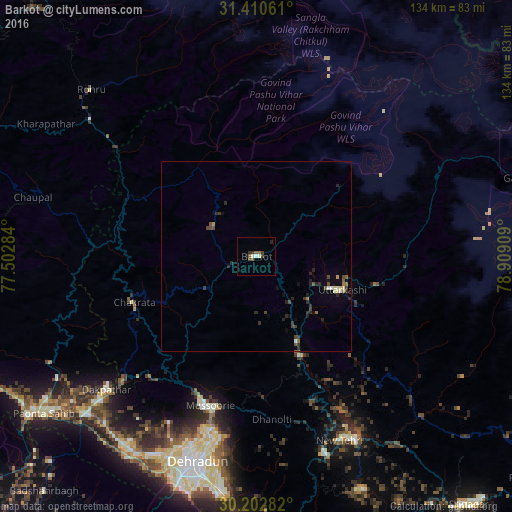
Analysis of Barkot night lights 2016
Square area 10x10 km:
 0.35%
0.35%90-99
1.75%80-89
0%70-79
0%60-69
0.17%50-59
1.92%40-49
2.1%30-39
1.75%20-29
1.05%10-19
0.7%0-9
90.21%Square area 50x50 km:
0.08%90-99
0.18%80-89
0.12%70-79
0.03%60-69
0.18%50-59
0.27%40-49
0.41%30-39
0.36%20-29
0.75%10-19
0.34%0-9
97.27%Clear (daylight) street map image can be seen on geolist.org.
Map coordinates:
31° 24' 38.2" North, 77° 30' 10.2" East
30° 48' 31" North, 78° 12' 21.5" East
30° 12' 10.2" North, 78° 54' 32.7" East
Some cities around Barkot sort by population:
• Dehra Dūn
56.3 km =35 mi,  197°
197°
• Rāipur
56.4 km =35 mi,  191°
191°
• Tehri
53.4 km =33.2 mi,  150°
150°
• Mussoorie
41.4 km =25.7 mi, 198°
• Uttarkāshi
24.3 km =15.1 mi,  111°
111°
• Vikāsnagar
56 km =34.8 mi,  227°
227°
• Harbatpur
60.6 km =37.7 mi, 227°
• Rohru
61.4 km =38.2 mi,  315°
315°
1276917 (p: 7,725)
Sources (retrieved 2019-11-25):
» Earth at Night: Flat Maps 2012, 2016