Udaipura night lights from space
Night Light of Udaipura (Madhya Pradesh) from space (India) Src. Average luminocity for 10x10km area is 19.2178% and for 50x50km: 7.8832%.
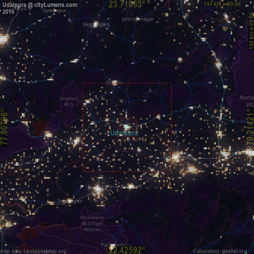
Analysis of Udaipura night lights 2016
Square area 10x10 km:
 1.7%
1.7%90-99
2.08%80-89
1.52%70-79
1.52%60-69
4.36%50-59
2.84%40-49
2.65%30-39
1.52%20-29
2.46%10-19
18.75%0-9
60.61%Square area 50x50 km:
0.3%90-99
0.51%80-89
0.52%70-79
0.73%60-69
1.41%50-59
1.55%40-49
1.44%30-39
1.85%20-29
2.28%10-19
3.93%0-9
85.48%Clear (daylight) street map image can be seen on geolist.org.
Map coordinates:
23° 43' 10.7" North, 77° 48' 28.7" East
23° 4' 27.6" North, 78° 30' 39.9" East
22° 25' 33.3" North, 79° 12' 51.2" East
Some cities around Udaipura sort by population:
• Gādarwāra
32.7 km =20.3 mi,  120°
120°
• Begamganj
60.9 km =37.8 mi,  343°
343°
• Kareli
59.3 km =36.8 mi,  107°
107°
• Deori Khās
62.4 km =38.8 mi,  55°
55°
• Sohāgpur
52.7 km =32.7 mi,  217°
217°
• Chichli
41.9 km =26 mi,  129°
129°
• Sultānpur
59.4 km =36.9 mi,  276°
276°
• Jaithāri
18.3 km =11.4 mi,  35°
35°
1253984 (p: 15,473)
Sources (retrieved 2019-11-25):
» Earth at Night: Flat Maps 2012, 2016