Chichli night lights from space
Night Light of Chichli (Madhya Pradesh) from space (India) Src. Average luminocity for 10x10km area is 24.752% and for 50x50km: 10.1132%.
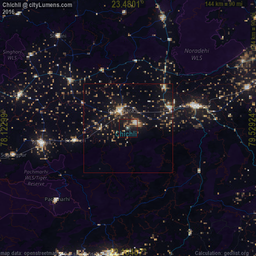
Analysis of Chichli night lights 2016
Square area 10x10 km:
 2.98%
2.98%90-99
2.58%80-89
2.98%70-79
0.99%60-69
3.97%50-59
3.57%40-49
2.98%30-39
6.94%20-29
5.56%10-19
30.36%0-9
37.1%Square area 50x50 km:
0.6%90-99
0.93%80-89
0.89%70-79
0.73%60-69
1.69%50-59
1.85%40-49
1.88%30-39
2.17%20-29
2.83%10-19
10.45%0-9
75.97%Clear (daylight) street map image can be seen on geolist.org.
Map coordinates:
23° 28' 48.4" North, 78° 7' 22.8" East
22° 50' 1.1" North, 78° 49' 34" East
22° 11' 2.7" North, 79° 31' 45.3" East
Some cities around Chichli sort by population:
• Narsimhapur
38.8 km =24.1 mi,  70°
70°
• Gādarwāra
10.8 km =6.7 mi,  337°
337°
• Kareli
26 km =16.2 mi, 69°
• Deori Khās
64.9 km =40.3 mi,  17°
17°
• Sohāgpur
66.4 km =41.3 mi,  257°
257°
• Udaipura
41.9 km =26 mi,  309°
309°
• Harrai
47.4 km =29.5 mi,  120°
120°
• Jaithāri
47 km =29.2 mi,  332°
332°
1274267 (p: 10,225)
Sources (retrieved 2019-11-25):
» Earth at Night: Flat Maps 2012, 2016