Jaithāri night lights from space
Night Light of Jaithāri (Madhya Pradesh) from space (India) Src. Average luminocity for 10x10km area is 0.5682% and for 50x50km: 4.4703%.
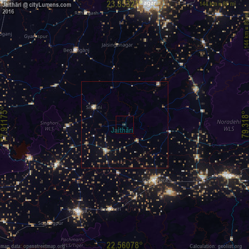
Analysis of Jaithāri night lights 2016
Square area 10x10 km:
 0%
0%90-99
0%80-89
0%70-79
0%60-69
0%50-59
0%40-49
0%30-39
1.33%20-29
0.19%10-19
0%0-9
98.48%Square area 50x50 km:
0.17%90-99
0.32%80-89
0.37%70-79
0.38%60-69
0.82%50-59
0.88%40-49
0.89%30-39
0.94%20-29
1.42%10-19
1.71%0-9
92.11%Clear (daylight) street map image can be seen on geolist.org.
Map coordinates:
23° 51' 11.6" North, 77° 54' 42.3" East
23° 12' 30.8" North, 78° 36' 53.5" East
22° 33' 38.8" North, 79° 19' 4.8" East
Some cities around Jaithāri sort by population:
• Narsimhapur
64.9 km =40.3 mi,  116°
116°
• Gādarwāra
36.2 km =22.5 mi,  151°
151°
• Begamganj
51.7 km =32.1 mi,  327°
327°
• Kareli
56.3 km =35 mi,  125°
125°
• Deori Khās
45.7 km =28.4 mi,  63°
63°
• Udaipura
18.3 km =11.4 mi,  215°
215°
• Dhāna
65 km =40.4 mi,  22°
22°
• Chichli
47 km =29.2 mi, 152°
1269495 (p: 8,386)
Sources (retrieved 2019-11-25):
» Earth at Night: Flat Maps 2012, 2016