Tirumullaivāsal night lights from space
Night Light of Tirumullaivāsal (Tamil Nadu) from space (India) Src. Average luminocity for 10x10km area is 6.5606% and for 50x50km: 6.1777%.
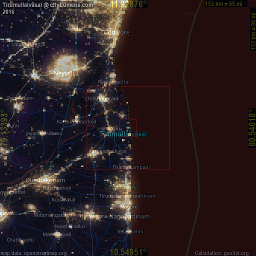
Analysis of Tirumullaivāsal night lights 2016
Square area 10x10 km:
 0%
0%90-99
0%80-89
0%70-79
1.73%60-69
1.08%50-59
1.52%40-49
3.25%30-39
0.87%20-29
1.95%10-19
0.43%0-9
89.18%Square area 50x50 km:
0.08%90-99
0.56%80-89
0.51%70-79
0.89%60-69
0.38%50-59
1.07%40-49
1.6%30-39
1.33%20-29
2.37%10-19
5.63%0-9
85.57%Clear (daylight) street map image can be seen on geolist.org.
Map coordinates:
11° 55' 43.5" North, 79° 8' 2.1" East
11° 14' 23.9" North, 79° 50' 13.4" East
10° 32' 58.2" North, 80° 32' 24.6" East
Some cities around Tirumullaivāsal sort by population:
• Mayiladuthurai
25 km =15.5 mi,  232°
232°
• Kāraikāl
35.9 km =22.3 mi,  180°
180°
• Chidambaram
23.8 km =14.8 mi,  318°
318°
• Sīrkāzhi
11 km =6.8 mi,  268°
268°
• Tharangambadi
23.7 km =14.7 mi, 175°
• Kīl Bhuvanagiri
30.5 km =19 mi, 317°
• Annāmalainagar
21.1 km =13.1 mi,  327°
327°
• Ālappākkam
41.9 km =26 mi,  342°
342°
1254367 (p: 13,234)
Sources (retrieved 2019-11-25):
» Earth at Night: Flat Maps 2012, 2016