Ālappākkam night lights from space
Night Light of Ālappākkam (Tamil Nadu) from space (India) Src. Average luminocity for 10x10km area is 12.6255% and for 50x50km: 17.6524%.
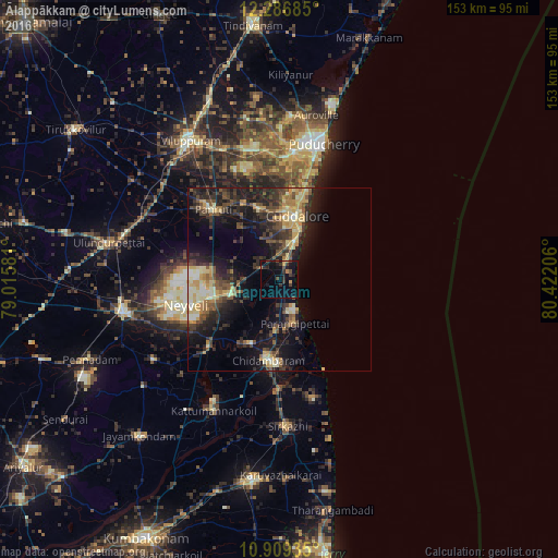
Analysis of Ālappākkam night lights 2016
Square area 10x10 km:
 0%
0%90-99
0%80-89
0.65%70-79
1.95%60-69
1.3%50-59
0%40-49
3.46%30-39
5.84%20-29
4.76%10-19
13.42%0-9
68.61%Square area 50x50 km:
0.49%90-99
2.19%80-89
3.14%70-79
2.87%60-69
1.63%50-59
2.85%40-49
3.78%30-39
4.12%20-29
6.95%10-19
12.62%0-9
59.36%Clear (daylight) street map image can be seen on geolist.org.
Map coordinates:
12° 17' 12.7" North, 79° 0' 56.9" East
11° 35' 56.2" North, 79° 43' 8.1" East
10° 54' 33.7" North, 80° 25' 19.4" East
Some cities around Ālappākkam sort by population:
• Cuddalore
18.2 km =11.3 mi,  16°
16°
• Chidambaram
22.4 km =13.9 mi,  187°
187°
• Panruti
26.8 km =16.7 mi,  317°
317°
• Nellikkuppam
20.3 km =12.6 mi,  344°
344°
• Kurinjippādi
15 km =9.3 mi,  248°
248°
• Kīl Bhuvanagiri
19.1 km =11.9 mi,  204°
204°
• Valavanur
38.8 km =24.1 mi, 337°
• Annāmalainagar
22.2 km =13.8 mi,  175°
175°
1279056 (p: 5,585)
Sources (retrieved 2019-11-25):
» Earth at Night: Flat Maps 2012, 2016