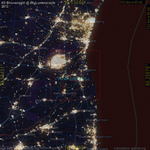
Kīl Bhuvanagiri night lights from space
Night Light of Kīl Bhuvanagiri (Tamil Nadu) from space (India) Src. Average luminocity for 10x10km area is 17.1732% and for 50x50km: 17.1363%.
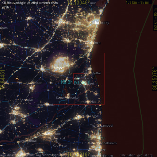
Analysis of Kīl Bhuvanagiri night lights 2016
Square area 10x10 km:
 0.65%
0.65%90-99
2.16%80-89
2.16%70-79
2.81%60-69
0%50-59
1.73%40-49
3.68%30-39
3.25%20-29
4.98%10-19
24.24%0-9
54.33%Square area 50x50 km:
1.1%90-99
3.36%80-89
2.87%70-79
2.05%60-69
1.49%50-59
2.44%40-49
3.06%30-39
3.24%20-29
5.38%10-19
9.63%0-9
65.38%Clear (daylight) street map image can be seen on geolist.org.
Map coordinates:
12° 7' 49.7" North, 78° 56' 40.2" East
11° 26' 31.8" North, 79° 38' 51.5" East
10° 45' 7.9" North, 80° 21' 2.7" East
Some cities around Kīl Bhuvanagiri sort by population:
• Vriddhāchalam
36.3 km =22.6 mi,  283°
283°
• Chidambaram
6.7 km =4.2 mi,  134°
134°
• Sīrkāzhi
24.7 km =15.3 mi,  157°
157°
• Kurinjippādi
13.5 km =8.4 mi,  332°
332°
• Tirumullaivāsal
30.5 km =19 mi,  137°
137°
• Srīmushnam
27 km =16.8 mi,  260°
260°
• Annāmalainagar
10.5 km =6.5 mi,  116°
116°
• Ālappākkam
19.1 km =11.9 mi,  24°
24°
1275768 (p: 20,656)
Sources (retrieved 2019-11-25):
» Earth at Night: Flat Maps 2012, 2016