Soron night lights from space
Night Light of Soron (Uttar Pradesh) from space (India) Src. Average luminocity for 10x10km area is 9.8977% and for 50x50km: 8.5516%.

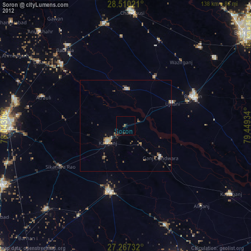
Analysis of Soron night lights 2016
Square area 10x10 km:
 0.95%
0.95%90-99
1.33%80-89
0%70-79
1.52%60-69
0.76%50-59
1.52%40-49
2.27%30-39
1.7%20-29
1.14%10-19
7.77%0-9
81.06%Square area 50x50 km:
0.26%90-99
0.55%80-89
0.75%70-79
0.7%60-69
0.94%50-59
1.36%40-49
2.15%30-39
3.22%20-29
3.58%10-19
6.25%0-9
80.24%Clear (daylight) street map image can be seen on geolist.org.
Map coordinates:
28° 30' 36.8" North, 78° 2' 35.1" East
27° 53' 26" North, 78° 44' 46.4" East
27° 16' 2.4" North, 79° 26' 57.6" East
Some cities around Soron sort by population:
• Kāsganj
13.4 km =8.3 mi,  227°
227°
• Sahaswān
20.2 km =12.6 mi,  1°
1°
• Ujhāni
28.6 km =17.8 mi,  64°
64°
• Ganj Dundwāra
26 km =16.2 mi,  132°
132°
• Bilsi
31.1 km =19.3 mi,  31°
31°
• Sahāwar
13.6 km =8.5 mi,  140°
140°
• Mārahra
24.4 km =15.2 mi, 225°
• Amānpur
19.8 km =12.3 mi,  182°
182°
1255704 (p: 28,683)
Sources (retrieved 2019-11-25):
» Earth at Night: Flat Maps 2012, 2016