Amānpur night lights from space
Night Light of Amānpur (Uttar Pradesh) from space (India) Src. Average luminocity for 10x10km area is 5.9444% and for 50x50km: 9.6855%.
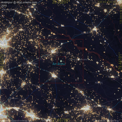
Analysis of Amānpur night lights 2016
Square area 10x10 km:
 0%
0%90-99
0%80-89
1.59%70-79
0%60-69
0%50-59
1.19%40-49
0.4%30-39
2.58%20-29
3.97%10-19
2.58%0-9
87.7%Square area 50x50 km:
0.32%90-99
0.86%80-89
0.82%70-79
0.62%60-69
1.02%50-59
1.4%40-49
2.75%30-39
3.46%20-29
3.84%10-19
8.47%0-9
76.43%Clear (daylight) street map image can be seen on geolist.org.
Map coordinates:
28° 19' 58.5" North, 78° 2' 5.1" East
27° 42' 44" North, 78° 44' 16.4" East
27° 5' 16.7" North, 79° 26' 27.6" East
Some cities around Amānpur sort by population:
• Kāsganj
14.1 km =8.8 mi,  319°
319°
• Ganj Dundwāra
20.1 km =12.5 mi,  83°
83°
• Soron
19.8 km =12.3 mi,  2°
2°
• Sahāwar
13.3 km =8.3 mi,  45°
45°
• Mārahra
16.9 km =10.5 mi,  279°
279°
• Sidhpura
15.6 km =9.7 mi,  124°
124°
• Patiāli
25.7 km =16 mi,  95°
95°
• Sakīt
31.1 km =19.3 mi,  172°
172°
1278921 (p: 10,362)
Sources (retrieved 2019-11-25):
» Earth at Night: Flat Maps 2012, 2016