Sikandra night lights from space
Night Light of Sikandra (Uttar Pradesh) from space (India) Src. Average luminocity for 10x10km area is 12.8542% and for 50x50km: 7.5072%.
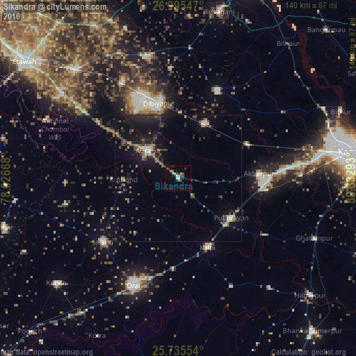
Analysis of Sikandra night lights 2016
Square area 10x10 km:
 0.76%
0.76%90-99
1.7%80-89
1.33%70-79
1.52%60-69
1.7%50-59
0.57%40-49
2.27%30-39
5.87%20-29
2.46%10-19
1.7%0-9
80.11%Square area 50x50 km:
0.34%90-99
0.54%80-89
0.45%70-79
0.57%60-69
1.07%50-59
1.47%40-49
1.6%30-39
2.02%20-29
2.57%10-19
6.58%0-9
82.78%Clear (daylight) street map image can be seen on geolist.org.
Map coordinates:
26° 59' 43.7" North, 78° 55' 36" East
26° 22' 2" North, 79° 37' 47.3" East
25° 44' 7.9" North, 80° 19' 58.5" East
Some cities around Sikandra sort by population:
• Auraiya
16.2 km =10.1 mi,  312°
312°
• Jālaun
38.3 km =23.8 mi,  229°
229°
• Kālpi
29.7 km =18.5 mi,  159°
159°
• Jhīnjhak
23.9 km =14.9 mi,  25°
25°
• Pukhrāyān
26.1 km =16.2 mi,  127°
127°
• Akbarpur
31.9 km =19.8 mi,  86°
86°
• Phaphūnd
30.6 km =19 mi,  327°
327°
• Rura
30.3 km =18.8 mi,  63°
63°
1256324 (p: 12,289)
Sources (retrieved 2019-11-25):
» Earth at Night: Flat Maps 2012, 2016