Phaphūnd night lights from space
Night Light of Phaphūnd (Uttar Pradesh) from space (India) Src. Average luminocity for 10x10km area is 48.161% and for 50x50km: 21.6253%.
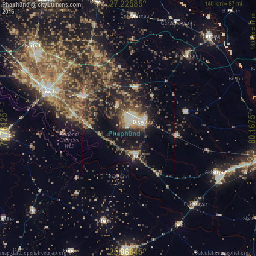
Analysis of Phaphūnd night lights 2016
Square area 10x10 km:
 6.63%
6.63%90-99
10.98%80-89
8.14%70-79
6.44%60-69
7.01%50-59
5.11%40-49
7.58%30-39
4.73%20-29
12.69%10-19
25%0-9
5.68%Square area 50x50 km:
1.24%90-99
2.64%80-89
1.83%70-79
2.15%60-69
3.29%50-59
4.27%40-49
6.1%30-39
6.1%20-29
7.92%10-19
15.57%0-9
48.89%Clear (daylight) street map image can be seen on geolist.org.
Map coordinates:
27° 13' 33.1" North, 78° 45' 40.5" East
26° 35' 56" North, 79° 27' 51.7" East
25° 58' 6.4" North, 80° 10' 3" East
Some cities around Phaphūnd sort by population:
• Auraiya
15.5 km =9.6 mi,  163°
163°
• Bharthana
29.5 km =18.3 mi,  305°
305°
• Bidhūna
23 km =14.3 mi,  10°
10°
• Jhīnjhak
27.2 km =16.9 mi,  98°
98°
• Bakewar
29.5 km =18.3 mi,  283°
283°
• Sikandra
30.6 km =19 mi,  147°
147°
• Lakhnā
32 km =19.9 mi, 279°
• Rāmpura
39.4 km =24.5 mi,  225°
225°
1259801 (p: 16,675)
Sources (retrieved 2019-11-25):
» Earth at Night: Flat Maps 2012, 2016