Rura night lights from space
Night Light of Rura (Uttar Pradesh) from space (India) Src. Average luminocity for 10x10km area is 5.7235% and for 50x50km: 8.4176%.
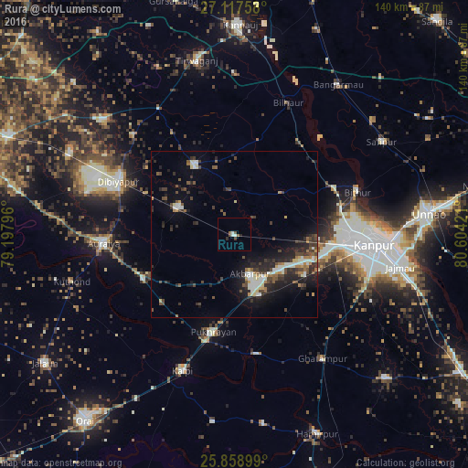
Analysis of Rura night lights 2016
Square area 10x10 km:
 1.33%
1.33%90-99
0.95%80-89
0%70-79
0%60-69
0%50-59
2.08%40-49
1.7%30-39
0%20-29
1.52%10-19
0%0-9
92.42%Square area 50x50 km:
0.72%90-99
1.68%80-89
0.64%70-79
0.56%60-69
0.85%50-59
1.13%40-49
1.78%30-39
1.73%20-29
3.32%10-19
5.49%0-9
82.11%Clear (daylight) street map image can be seen on geolist.org.
Map coordinates:
27° 7' 3.3" North, 79° 11' 52.7" East
26° 29' 24" North, 79° 54' 3.9" East
25° 51' 32.4" North, 80° 36' 15.2" East
Some cities around Rura sort by population:
• Auraiya
39.1 km =24.3 mi,  265°
265°
• Jhīnjhak
18.4 km =11.4 mi,  295°
295°
• Pukhrāyān
30.3 km =18.8 mi,  192°
192°
• Bilhaur
42.5 km =26.4 mi,  22°
22°
• Akbarpur
12.8 km =8 mi,  157°
157°
• Sikandra
30.3 km =18.8 mi,  243°
243°
• Nawābganj
40.6 km =25.2 mi,  88°
88°
• Bithūr
39 km =24.2 mi,  70°
70°
1257940 (p: 15,908)
Sources (retrieved 2019-11-25):
» Earth at Night: Flat Maps 2012, 2016