Sardulgarh night lights from space
Night Light of Sardulgarh (Punjab) from space (India) Src. Average luminocity for 10x10km area is 12.6964% and for 50x50km: 7.3814%.
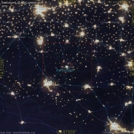
Analysis of Sardulgarh night lights 2016
Square area 10x10 km:
 0.4%
0.4%90-99
0.99%80-89
0.99%70-79
0%60-69
3.17%50-59
2.78%40-49
3.17%30-39
3.97%20-29
2.78%10-19
2.38%0-9
79.37%Square area 50x50 km:
0.58%90-99
1.13%80-89
0.75%70-79
0.32%60-69
0.78%50-59
1.3%40-49
1.78%30-39
1.89%20-29
2.31%10-19
5.08%0-9
84.09%Clear (daylight) street map image can be seen on geolist.org.
Map coordinates:
30° 18' 4.2" North, 74° 31' 58.7" East
29° 41' 32.1" North, 75° 14' 9.9" East
29° 4' 46.5" North, 75° 56' 21.2" East
Some cities around Sardulgarh sort by population:
• Sirsa
26.6 km =16.5 mi,  228°
228°
• Mānsa
36.6 km =22.7 mi,  25°
25°
• Fatehābād
28.9 km =18 mi,  132°
132°
• Maur
43.5 km =27 mi,  1°
1°
• Kālānwāli
30.1 km =18.7 mi,  302°
302°
• Ratia
32.9 km =20.4 mi,  90°
90°
• Budhlāda
40.9 km =25.4 mi,  50°
50°
• Rānia
42.9 km =26.7 mi,  244°
244°
1257191 (p: 17,270)
Sources (retrieved 2019-11-25):
» Earth at Night: Flat Maps 2012, 2016