Ratia night lights from space
Night Light of Ratia (Haryana) from space (India) Src. Average luminocity for 10x10km area is 17.6349% and for 50x50km: 5.1972%.
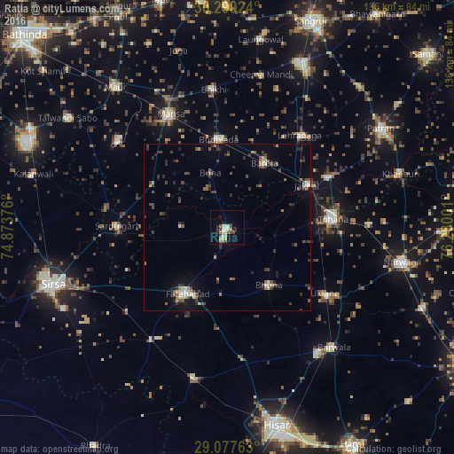
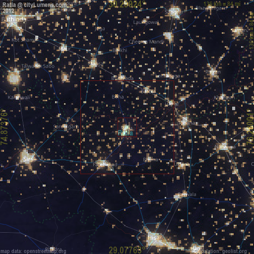
Analysis of Ratia night lights 2016
Square area 10x10 km:
 1.59%
1.59%90-99
2.58%80-89
3.57%70-79
1.79%60-69
2.38%50-59
2.78%40-49
1.98%30-39
2.38%20-29
2.78%10-19
3.77%0-9
74.4%Square area 50x50 km:
0.33%90-99
0.43%80-89
0.49%70-79
0.27%60-69
0.72%50-59
0.96%40-49
1.25%30-39
1.42%20-29
1.26%10-19
2.25%0-9
90.62%Clear (daylight) street map image can be seen on geolist.org.
Map coordinates:
30° 17' 57.3" North, 74° 52' 25.5" East
29° 41' 25" North, 75° 34' 36.8" East
29° 4' 39.5" North, 76° 16' 48" East
Some cities around Ratia sort by population:
• Gorakhpur
28.5 km =17.7 mi,  161°
161°
• Fatehābād
22.7 km =14.1 mi,  211°
211°
• Tohāna
31.7 km =19.7 mi,  85°
85°
• Budhlāda
26.5 km =16.5 mi,  356°
356°
• Sardulgarh
32.9 km =20.4 mi,  270°
270°
• Jākhal
26.6 km =16.5 mi,  63°
63°
• Inda Chhoi
21.4 km =13.3 mi,  105°
105°
• Akālgarh
33.6 km =20.9 mi, 64°
1258347 (p: 26,524)
Sources (retrieved 2019-11-25):
» Earth at Night: Flat Maps 2012, 2016