Sanaur night lights from space
Night Light of Sanaur (Punjab) from space (India) Src. Average luminocity for 10x10km area is 42.2656% and for 50x50km: 18.6191%.
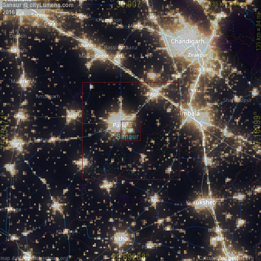
Analysis of Sanaur night lights 2016
Square area 10x10 km:
100  4.21%
4.21%
90-99 10.81%
80-89 6.96%
70-79 4.03%
60-69 4.76%
50-59 5.31%
40-49 10.07%
30-39 5.86%
20-29 8.61%
10-19 23.08%
0-9 16.3%
4.21%90-99
10.81%80-89
6.96%70-79
4.03%60-69
4.76%50-59
5.31%40-49
10.07%30-39
5.86%20-29
8.61%10-19
23.08%0-9
16.3%Square area 50x50 km:
100 1.45%
90-99 2.94%
80-89 2.61%
70-79 1.31%
60-69 1.64%
50-59 2.92%
40-49 4.01%
30-39 4.2%
20-29 7.28%
10-19 11.7%
0-9 59.95%
1.45%90-99
2.94%80-89
2.61%70-79
1.31%60-69
1.64%50-59
2.92%40-49
4.01%30-39
4.2%20-29
7.28%10-19
11.7%0-9
59.95%Clear (daylight) street map image can be seen on geolist.org.
Map coordinates:
30° 54' 25.2" North, 75° 45' 17.1" East
30° 18' 6.6" North, 76° 27' 28.3" East
29° 41' 34.4" North, 77° 9' 39.6" East
Some cities around Sanaur sort by population:
• Patiāla
7.4 km =4.6 mi,  301°
301°
• Ambāla
33.3 km =20.7 mi,  78°
78°
• Rājpura
23.5 km =14.6 mi,  33°
33°
• Nābha
30.4 km =18.9 mi,  285°
285°
• Sirhind
38.6 km =24 mi,  349°
349°
• Pehowa
37.8 km =23.5 mi,  161°
161°
• Banūr
37.6 km =23.4 mi,  41°
41°
• Ghanaur
15.1 km =9.4 mi, 77°
1257482 (p: 18,401)
Sources (retrieved 2019-11-25):
» Earth at Night: Flat Maps 2012, 2016