Banūr night lights from space
Night Light of Banūr (Punjab) from space (India) Src. Average luminocity for 10x10km area is 39.5147% and for 50x50km: 46.5197%.
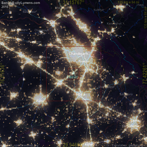
Analysis of Banūr night lights 2016
Square area 10x10 km:
100  0.73%
0.73%
90-99 4.76%
80-89 4.4%
70-79 2.56%
60-69 7.33%
50-59 4.03%
40-49 10.62%
30-39 16.67%
20-29 40.84%
10-19 8.06%
0-9 0%
0.73%90-99
4.76%80-89
4.4%70-79
2.56%60-69
7.33%50-59
4.03%40-49
10.62%30-39
16.67%20-29
40.84%10-19
8.06%0-9
0%Square area 50x50 km:
100 8.35%
90-99 11.1%
80-89 7%
70-79 3.37%
60-69 4.98%
50-59 7.07%
40-49 8.11%
30-39 8.16%
20-29 11.21%
10-19 14.26%
0-9 16.39%
8.35%90-99
11.1%80-89
7%70-79
3.37%60-69
4.98%50-59
7.07%40-49
8.11%30-39
8.16%20-29
11.21%10-19
14.26%0-9
16.39%Clear (daylight) street map image can be seen on geolist.org.
Map coordinates:
31° 9' 27.6" North, 76° 0' 58.9" East
30° 33' 14.7" North, 76° 43' 10.1" East
29° 56' 48.1" North, 77° 25' 21.4" East
Some cities around Banūr sort by population:
• Chandigarh
21.3 km =13.2 mi,  18°
18°
• Panchkula
20 km =12.4 mi,  38°
38°
• Ambāla
22.7 km =14.1 mi,  160°
160°
• Mohali
14 km =8.7 mi,  1°
1°
• Rājpura
14.8 km =9.2 mi,  235°
235°
• Kharar
22.5 km =14 mi,  342°
342°
• Basi
12.6 km =7.8 mi,  72°
72°
• Ghanaur
26.9 km =16.7 mi,  202°
202°
1277200 (p: 17,349)
Sources (retrieved 2019-11-25):
» Earth at Night: Flat Maps 2012, 2016