Rājur night lights from space
Night Light of Rājur (Maharashtra) from space (India) Src. Average luminocity for 10x10km area is 13.7222% and for 50x50km: 11.2701%.
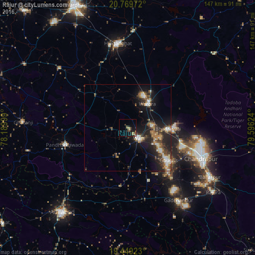
Analysis of Rājur night lights 2016
Square area 10x10 km:
 0.2%
0.2%90-99
0.2%80-89
3.37%70-79
1.59%60-69
1.39%50-59
3.37%40-49
3.17%30-39
1.59%20-29
5.36%10-19
11.9%0-9
67.86%Square area 50x50 km:
1.26%90-99
1.43%80-89
1.1%70-79
1.11%60-69
1.47%50-59
1.74%40-49
2.23%30-39
2.56%20-29
4.65%10-19
8.75%0-9
73.69%Clear (daylight) street map image can be seen on geolist.org.
Map coordinates:
20° 46' 11" North, 78° 11' 24" East
20° 6' 39.1" North, 78° 53' 35.2" East
19° 26' 57.2" North, 79° 35' 46.5" East
Some cities around Rājur sort by population:
• Chānda
45.6 km =28.3 mi,  112°
112°
• Hinganghāt
49 km =30.4 mi,  353°
353°
• Ballālpur
55.7 km =34.6 mi,  121°
121°
• Wani
8.8 km =5.5 mi,  134°
134°
• Warora
17.4 km =10.8 mi,  41°
41°
• Ghugus
29.9 km =18.6 mi, 130°
• Chāndur
51 km =31.7 mi,  145°
145°
• Durgāpur
44.4 km =27.6 mi, 105°
1258788 (p: 11,934)
Sources (retrieved 2019-11-25):
» Earth at Night: Flat Maps 2012, 2016