Patnāgarh night lights from space
Night Light of Patnāgarh (Odisha) from space (India) Src. Average luminocity for 10x10km area is 18.6174% and for 50x50km: 1.9491%.
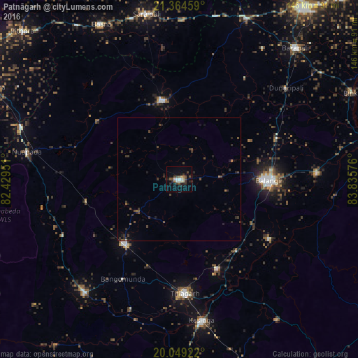
Analysis of Patnāgarh night lights 2016
Square area 10x10 km:
 2.84%
2.84%90-99
2.84%80-89
1.14%70-79
0.76%60-69
1.52%50-59
3.03%40-49
3.79%30-39
4.73%20-29
4.17%10-19
7.2%0-9
67.99%Square area 50x50 km:
0.12%90-99
0.12%80-89
0.06%70-79
0.06%60-69
0.21%50-59
0.29%40-49
0.63%30-39
0.79%20-29
1.09%10-19
0.63%0-9
96%Clear (daylight) street map image can be seen on geolist.org.
Map coordinates:
21° 21' 52.5" North, 82° 25' 46.2" East
20° 42' 30" North, 83° 7' 57.5" East
20° 2' 57.2" North, 83° 50' 8.7" East
Some cities around Patnāgarh sort by population:
• Balāngīr
37.2 km =23.1 mi,  90°
90°
• Titlāgarh
46.6 km =29 mi,  177°
177°
• Kantābānji
34.7 km =21.6 mi,  219°
219°
• Saraipali
68.8 km =42.8 mi,  349°
349°
• Kesinga
58.6 km =36.4 mi,  171°
171°
• Padampur
33.1 km =20.6 mi, 347°
• Kharhiāl
60.7 km =37.7 mi, 219°
• Tarabha
56.4 km =35 mi, 87°
1260082 (p: 19,582)
Sources (retrieved 2019-11-25):
» Earth at Night: Flat Maps 2012, 2016