Saraipali night lights from space
Night Light of Saraipali (Chhattisgarh) from space (India) Src. Average luminocity for 10x10km area is 28.6837% and for 50x50km: 3.9696%.
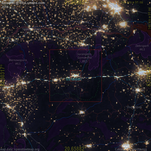
Analysis of Saraipali night lights 2016
Square area 10x10 km:
 3.41%
3.41%90-99
2.65%80-89
0.95%70-79
3.6%60-69
3.79%50-59
7.58%40-49
6.06%30-39
4.92%20-29
7.58%10-19
36.74%0-9
22.73%Square area 50x50 km:
0.23%90-99
0.24%80-89
0.17%70-79
0.39%60-69
0.35%50-59
0.61%40-49
0.93%30-39
1.55%20-29
1.35%10-19
3.36%0-9
90.82%Clear (daylight) street map image can be seen on geolist.org.
Map coordinates:
21° 58' 7.9" North, 82° 18' 11.4" East
21° 18' 55.1" North, 83° 0' 22.6" East
20° 39' 31.8" North, 83° 42' 33.9" East
Some cities around Saraipali sort by population:
• Bargarh
63.5 km =39.5 mi,  88°
88°
• Barpāli
61.8 km =38.4 mi,  103°
103°
• Padampur
35.6 km =22.1 mi,  170°
170°
• Sārangarh
31 km =19.3 mi,  13°
13°
• Deori
43 km =26.7 mi,  290°
290°
• Basna
19 km =11.8 mi,  257°
257°
• Seorīnārāyan
62.1 km =38.6 mi,  316°
316°
• Pithora
51.2 km =31.8 mi, 261°
1257259 (p: 18,394)
Sources (retrieved 2019-11-25):
» Earth at Night: Flat Maps 2012, 2016