Pathalgaon night lights from space
Night Light of Pathalgaon (Chhattisgarh) from space (India) Src. Average luminocity for 10x10km area is 20.6667% and for 50x50km: 1.7542%.
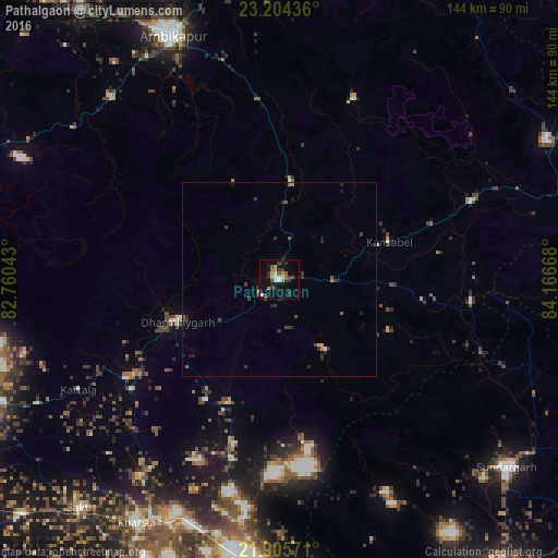
Analysis of Pathalgaon night lights 2016
Square area 10x10 km:
 1.52%
1.52%90-99
3.03%80-89
2.27%70-79
1.52%60-69
3.98%50-59
2.08%40-49
3.79%30-39
5.68%20-29
4.73%10-19
9.47%0-9
61.93%Square area 50x50 km:
0.09%90-99
0.13%80-89
0.13%70-79
0.16%60-69
0.22%50-59
0.31%40-49
0.31%30-39
0.71%20-29
0.56%10-19
0.8%0-9
96.58%Clear (daylight) street map image can be seen on geolist.org.
Map coordinates:
23° 12' 15.7" North, 82° 45' 37.5" East
22° 33' 23.6" North, 83° 27' 48.8" East
21° 54' 20.6" North, 84° 10' 0" East
Some cities around Pathalgaon sort by population:
• Korba
82.2 km =51.1 mi,  253°
253°
• Raigarh
73.6 km =45.7 mi,  185°
185°
• Ambikāpur
68.3 km =42.4 mi,  336°
336°
• Sundargarh
76.3 km =47.4 mi,  129°
129°
• Jashpurnagar
78.4 km =48.7 mi,  61°
61°
• Saktī
78.4 km =48.7 mi,  221°
221°
• Kharsia
73.1 km =45.4 mi,  210°
210°
• Gharghoda
44 km =27.3 mi,  195°
195°
1260141 (p: 15,394)
Sources (retrieved 2019-11-25):
» Earth at Night: Flat Maps 2012, 2016