Kharsia night lights from space
Night Light of Kharsia (Chhattisgarh) from space (India) Src. Average luminocity for 10x10km area is 60.125% and for 50x50km: 26.8128%.
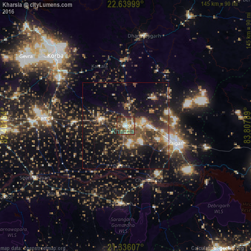
Analysis of Kharsia night lights 2016
Square area 10x10 km:
 6.75%
6.75%90-99
9.92%80-89
8.53%70-79
11.9%60-69
5.95%50-59
15.48%40-49
19.44%30-39
15.08%20-29
6.94%10-19
0%0-9
0%Square area 50x50 km:
1.68%90-99
2.8%80-89
2.09%70-79
3.11%60-69
3.46%50-59
6.51%40-49
7.65%30-39
7.19%20-29
10.63%10-19
19.42%0-9
35.47%Clear (daylight) street map image can be seen on geolist.org.
Map coordinates:
22° 38' 24" North, 82° 24' 5.9" East
21° 59' 22.3" North, 83° 6' 17.1" East
21° 20' 9.9" North, 83° 48' 28.4" East
Some cities around Kharsia sort by population:
• Korba
57.8 km =35.9 mi,  313°
313°
• Raigarh
31.8 km =19.8 mi,  108°
108°
• Chāmpa
47.9 km =29.8 mi,  276°
276°
• Jānjgīr
54.4 km =33.8 mi,  272°
272°
• Saktī
15.4 km =9.6 mi,  285°
285°
• Sārangarh
44.9 km =27.9 mi,  183°
183°
• Seorīnārāyan
60.7 km =37.7 mi,  240°
240°
• Gharghoda
32.7 km =20.3 mi,  51°
51°
1266872 (p: 18,256)
Sources (retrieved 2019-11-25):
» Earth at Night: Flat Maps 2012, 2016