Gharghoda night lights from space
Night Light of Gharghoda (Chhattisgarh) from space (India) Src. Average luminocity for 10x10km area is 19.1865% and for 50x50km: 18.5777%.
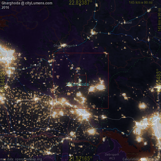
Analysis of Gharghoda night lights 2016
Square area 10x10 km:
 1.19%
1.19%90-99
1.98%80-89
1.59%70-79
3.17%60-69
3.17%50-59
2.98%40-49
2.58%30-39
3.97%20-29
3.57%10-19
17.66%0-9
58.13%Square area 50x50 km:
1.67%90-99
2.64%80-89
1.79%70-79
1.94%60-69
2.35%50-59
4.42%40-49
4.36%30-39
3.95%20-29
5.92%10-19
12.5%0-9
58.45%Clear (daylight) street map image can be seen on geolist.org.
Map coordinates:
22° 49' 25.9" North, 82° 38' 54.9" East
22° 10' 27.4" North, 83° 21' 6.1" East
21° 31' 17.9" North, 84° 3' 17.4" East
Some cities around Gharghoda sort by population:
• Korba
70.1 km =43.6 mi,  285°
285°
• Raigarh
31.1 km =19.3 mi,  171°
171°
• Brājarājnagar
70.5 km =43.8 mi,  124°
124°
• Sundargarh
70.5 km =43.8 mi,  95°
95°
• Saktī
43.5 km =27 mi,  247°
247°
• Kharsia
32.7 km =20.3 mi,  231°
231°
• Pathalgaon
44 km =27.3 mi,  15°
15°
• Sārangarh
71.2 km =44.2 mi,  203°
203°
1271361 (p: 8,512)
Sources (retrieved 2019-11-25):
» Earth at Night: Flat Maps 2012, 2016