Nirsā night lights from space
Night Light of Nirsā (Jharkhand) from space (India) Src. Average luminocity for 10x10km area is 82.2659% and for 50x50km: 45.9941%.
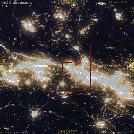
Analysis of Nirsā night lights 2016
Square area 10x10 km:
 26.79%
90-99
28.97%80-89
5.56%70-79
11.31%60-69
7.14%50-59
9.72%40-49
6.94%30-39
3.57%20-29
0%10-19
0%0-9
0%Square area 50x50 km:
11.35%90-99
10.64%80-89
4.99%70-79
4.68%60-69
5.34%50-59
5.58%40-49
5.82%30-39
6.73%20-29
10.57%10-19
15.15%0-9
19.14%Clear (daylight) street map image can be seen on geolist.org.
Map coordinates:
24° 25' 34.3" North, 86° 0' 13.7" East
23° 47' 3.8" North, 86° 42' 24.9" East
23° 8' 21.8" North, 87° 24' 36.2" East
Some cities around Nirsā sort by population:
• Kulti
15.1 km =9.4 mi,  112°
112°
• Dhanbād
26.9 km =16.7 mi,  274°
274°
• Jharia
30.1 km =18.7 mi,  260°
260°
• Chittaranjan
21.5 km =13.4 mi,  68°
68°
• Lakhyabad
13.7 km =8.5 mi,  197°
197°
• Jāmtāra
22.1 km =13.7 mi,  26°
26°
• Raghunathpur
27.5 km =17.1 mi,  187°
187°
• Gobindpur
20 km =12.4 mi,  286°
286°
1261283 (p: 14,124)
Sources (retrieved 2019-11-25):
» Earth at Night: Flat Maps 2012, 2016