Gobindpur night lights from space
Night Light of Gobindpur (Jharkhand) from space (India) Src. Average luminocity for 10x10km area is 74.8373% and for 50x50km: 43.2074%.
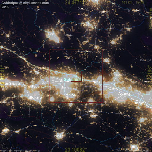
Analysis of Gobindpur night lights 2016
Square area 10x10 km:
 16.87%
90-99
22.62%80-89
11.9%70-79
11.31%60-69
11.71%50-59
7.54%40-49
8.13%30-39
3.37%20-29
4.56%10-19
1.98%0-9
0%Square area 50x50 km:
11.19%90-99
9.65%80-89
4.42%70-79
4.84%60-69
5.21%50-59
5.64%40-49
5.93%30-39
6.1%20-29
7.94%10-19
10.18%0-9
28.91%Clear (daylight) street map image can be seen on geolist.org.
Map coordinates:
24° 28' 37.6" North, 85° 48' 55.5" East
23° 50' 8" North, 86° 31' 6.7" East
23° 11' 27" North, 87° 13' 18" East
Some cities around Gobindpur sort by population:
• Dhanbād
8.5 km =5.3 mi,  244°
244°
• Jharia
14.9 km =9.3 mi,  225°
225°
• Kātrās
22.8 km =14.2 mi,  259°
259°
• Pāthardih
20.8 km =12.9 mi,  205°
205°
• Jāmadoba
17.9 km =11.1 mi,  222°
222°
• Sijua
20.3 km =12.6 mi,  250°
250°
• Nirsā
20 km =12.4 mi,  106°
106°
• Kenduadīh
15.9 km =9.9 mi, 245°
1271130 (p: 9,507)
Sources (retrieved 2019-11-25):
» Earth at Night: Flat Maps 2012, 2016