Nayāgarh night lights from space
Night Light of Nayāgarh (Odisha) from space (India) Src. Average luminocity for 10x10km area is 29.2639% and for 50x50km: 3.2818%.
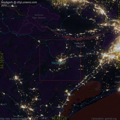
Analysis of Nayāgarh night lights 2016
Square area 10x10 km:
 2.18%
2.18%90-99
3.37%80-89
3.17%70-79
3.97%60-69
2.38%50-59
7.14%40-49
5.56%30-39
8.13%20-29
6.35%10-19
33.73%0-9
24.01%Square area 50x50 km:
0.1%90-99
0.29%80-89
0.15%70-79
0.33%60-69
0.3%50-59
0.69%40-49
0.86%30-39
1.18%20-29
1.27%10-19
2.39%0-9
92.43%Clear (daylight) street map image can be seen on geolist.org.
Map coordinates:
20° 47' 15.3" North, 84° 23' 35.3" East
20° 7' 43.8" North, 85° 5' 46.5" East
19° 28' 2.1" North, 85° 47' 57.8" East
Some cities around Nayāgarh sort by population:
• Khurda
54.6 km =33.9 mi,  83°
83°
• Polasara
56.7 km =35.2 mi,  211°
211°
• Bānapur
39.7 km =24.7 mi,  168°
168°
• Bālugaon
5.8 km =3.6 mi,  17°
17°
• Bānki
53.1 km =33 mi,  58°
58°
• Buguda
47.9 km =29.8 mi,  221°
221°
• Belaguntha
55.2 km =34.3 mi,  240°
240°
• Kantilo
27.7 km =17.2 mi, 21°
1261580 (p: 16,001)
Sources (retrieved 2019-11-25):
» Earth at Night: Flat Maps 2012, 2016