Bānki night lights from space
Night Light of Bānki (Odisha) from space (India) Src. Average luminocity for 10x10km area is 10.2784% and for 50x50km: 16.9262%.
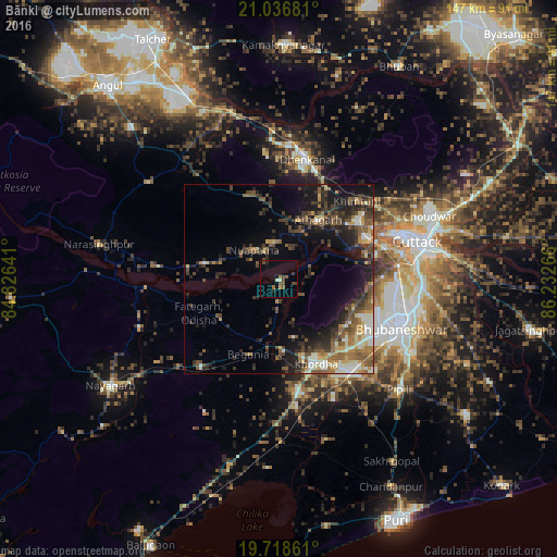
Analysis of Bānki night lights 2016
Square area 10x10 km:
 0%
0%90-99
0.95%80-89
0.57%70-79
0.76%60-69
1.52%50-59
2.27%40-49
4.17%30-39
1.52%20-29
1.7%10-19
1.7%0-9
84.85%Square area 50x50 km:
0.89%90-99
3.03%80-89
1.56%70-79
1.84%60-69
2.15%50-59
3.94%40-49
4.02%30-39
4.05%20-29
5.1%10-19
8.84%0-9
64.58%Clear (daylight) street map image can be seen on geolist.org.
Map coordinates:
21° 2' 12.5" North, 84° 49' 35.1" East
20° 22' 44.8" North, 85° 31' 46.3" East
19° 43' 7" North, 86° 13' 57.6" East
Some cities around Bānki sort by population:
• Bhubaneshwar
33.9 km =21.1 mi,  110°
110°
• Cuttack
37.7 km =23.4 mi,  75°
75°
• Dhenkānāl
31.7 km =19.7 mi,  12°
12°
• Jatani
30.6 km =19 mi,  142°
142°
• Khurda
23.6 km =14.7 mi,  157°
157°
• Āthagarh
18.8 km =11.7 mi,  33°
33°
• Pipili
43.2 km =26.8 mi,  133°
133°
• Kantilo
35.2 km =21.9 mi,  266°
266°
1277273 (p: 16,555)
Sources (retrieved 2019-11-25):
» Earth at Night: Flat Maps 2012, 2016