Bānapur night lights from space
Night Light of Bānapur (Odisha) from space (India) Src. Average luminocity for 10x10km area is 20.4029% and for 50x50km: 3.4196%.
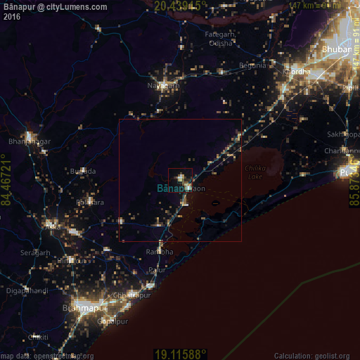
Analysis of Bānapur night lights 2016
Square area 10x10 km:
 1.45%
1.45%90-99
5.17%80-89
2.27%70-79
1.86%60-69
0.83%50-59
2.89%40-49
5.58%30-39
3.51%20-29
2.69%10-19
13.22%0-9
60.54%Square area 50x50 km:
0.12%90-99
0.29%80-89
0.34%70-79
0.32%60-69
0.2%50-59
0.68%40-49
0.95%30-39
0.81%20-29
1.42%10-19
1.29%0-9
93.56%Clear (daylight) street map image can be seen on geolist.org.
Map coordinates:
20° 26' 20.9" North, 84° 28' 2" East
19° 46' 44" North, 85° 10' 13.2" East
19° 6' 57.2" North, 85° 52' 24.5" East
Some cities around Bānapur sort by population:
• Polasara
38.5 km =23.9 mi,  255°
255°
• Bālugaon
44.8 km =27.8 mi,  352°
352°
• Nayāgarh
39.7 km =24.7 mi, 348°
• Purushottampur
41.5 km =25.8 mi,  226°
226°
• Buguda
39.8 km =24.7 mi,  274°
274°
• Kodala
29.6 km =18.4 mi, 234°
• Khallikot
20.8 km =12.9 mi,  205°
205°
• Rambha
30.1 km =18.7 mi,  194°
194°
1277426 (p: 17,499)
Sources (retrieved 2019-11-25):
» Earth at Night: Flat Maps 2012, 2016