Bālugaon night lights from space
Night Light of Bālugaon (Odisha) from space (India) Src. Average luminocity for 10x10km area is 17.0734% and for 50x50km: 3.6446%.
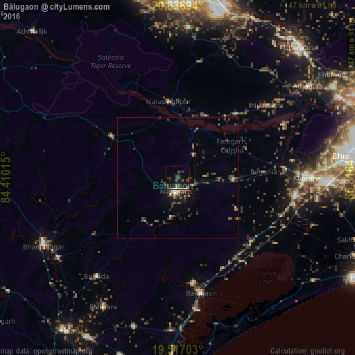
Analysis of Bālugaon night lights 2016
Square area 10x10 km:
 0.4%
0.4%90-99
0.79%80-89
0.79%70-79
1.98%60-69
0.79%50-59
5.75%40-49
4.17%30-39
6.35%20-29
5.56%10-19
21.43%0-9
51.98%Square area 50x50 km:
0.1%90-99
0.32%80-89
0.15%70-79
0.43%60-69
0.27%50-59
0.78%40-49
1.02%30-39
1.28%20-29
1.44%10-19
2.46%0-9
91.76%Clear (daylight) street map image can be seen on geolist.org.
Map coordinates:
20° 50' 13" North, 84° 24' 36.5" East
20° 10' 42.2" North, 85° 6' 47.8" East
19° 31' 1.3" North, 85° 48' 59" East
Some cities around Bālugaon sort by population:
• Jatani
62 km =38.5 mi,  91°
91°
• Khurda
52.5 km =32.6 mi, 89°
• Bānapur
44.8 km =27.8 mi,  172°
172°
• Bānki
48.8 km =30.3 mi,  62°
62°
• Nayāgarh
5.8 km =3.6 mi,  197°
197°
• Buguda
53.2 km =33.1 mi,  219°
219°
• Belaguntha
59.6 km =37 mi,  236°
236°
• Kantilo
22 km =13.7 mi,  21°
21°
1277514 (p: 17,238)
Sources (retrieved 2019-11-25):
» Earth at Night: Flat Maps 2012, 2016