Narwar night lights from space
Night Light of Narwar (Madhya Pradesh) from space (India) Src. Average luminocity for 10x10km area is 10.4962% and for 50x50km: 4.1274%.
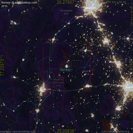
Analysis of Narwar night lights 2016
Square area 10x10 km:
 1.33%
1.33%90-99
2.84%80-89
0.38%70-79
0%60-69
1.52%50-59
0.19%40-49
2.84%30-39
0.76%20-29
3.03%10-19
0.57%0-9
86.55%Square area 50x50 km:
0.45%90-99
0.89%80-89
0.25%70-79
0.29%60-69
0.3%50-59
0.72%40-49
0.74%30-39
0.76%20-29
0.93%10-19
1.72%0-9
92.95%Clear (daylight) street map image can be seen on geolist.org.
Map coordinates:
26° 16' 33.9" North, 77° 12' 35.2" East
25° 38' 38" North, 77° 54' 46.4" East
25° 0' 30.1" North, 78° 36' 57.7" East
Some cities around Narwar sort by population:
• Shivpuri
35.1 km =21.8 mi,  225°
225°
• Datia
54.8 km =34.1 mi,  86°
86°
• Dabra
49.9 km =31 mi,  57°
57°
• Karera
30.4 km =18.9 mi,  132°
132°
• Bhitarwār
25.8 km =16 mi,  50°
50°
• Kolāras
56.1 km =34.9 mi,  212°
212°
• Tekanpur
53.8 km =33.4 mi,  43°
43°
• Antri
54.8 km =34.1 mi,  32°
32°
1261736 (p: 16,948)
Sources (retrieved 2019-11-25):
» Earth at Night: Flat Maps 2012, 2016