Tekanpur night lights from space
Night Light of Tekanpur (Madhya Pradesh) from space (India) Src. Average luminocity for 10x10km area is 32.8413% and for 50x50km: 17.2305%.
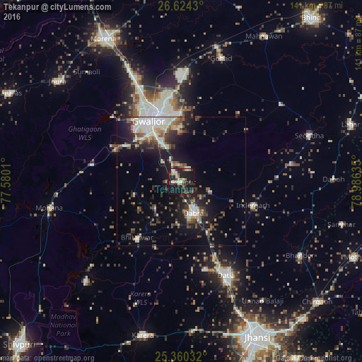
Analysis of Tekanpur night lights 2016
Square area 10x10 km:
 1.79%
1.79%90-99
7.94%80-89
2.78%70-79
3.17%60-69
4.56%50-59
2.98%40-49
4.37%30-39
7.94%20-29
11.51%10-19
45.63%0-9
7.34%Square area 50x50 km:
2.14%90-99
3.39%80-89
1.49%70-79
1.5%60-69
1.69%50-59
2.62%40-49
3.28%30-39
3.27%20-29
4.71%10-19
12.31%0-9
63.61%Clear (daylight) street map image can be seen on geolist.org.
Map coordinates:
26° 37' 27.5" North, 77° 34' 48.4" East
25° 59' 38.4" North, 78° 16' 59.6" East
25° 21' 37.2" North, 78° 59' 10.9" East
Some cities around Tekanpur sort by population:
• Gwalior
28.4 km =17.6 mi,  337°
337°
• Datia
39.8 km =24.7 mi,  153°
153°
• Dabra
13 km =8.1 mi,  157°
157°
• Gohadi
51.3 km =31.9 mi,  17°
17°
• Morār
26.5 km =16.5 mi,  347°
347°
• Mau
49.1 km =30.5 mi,  52°
52°
• Bhitarwār
28.3 km =17.6 mi,  217°
217°
• Antri
10.2 km =6.3 mi,  314°
314°
1254798 (p: 13,681)
Sources (retrieved 2019-11-25):
» Earth at Night: Flat Maps 2012, 2016