Antri night lights from space
Night Light of Antri (Madhya Pradesh) from space (India) Src. Average luminocity for 10x10km area is 21.7679% and for 50x50km: 21.5795%.
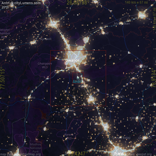
Analysis of Antri night lights 2016
Square area 10x10 km:
 0.99%
0.99%90-99
5.36%80-89
2.18%70-79
0.6%60-69
1.98%50-59
2.58%40-49
2.18%30-39
2.58%20-29
4.17%10-19
45.44%0-9
31.94%Square area 50x50 km:
3.71%90-99
4.91%80-89
2.17%70-79
1.9%60-69
2.05%50-59
3.15%40-49
3.29%30-39
3.34%20-29
5.29%10-19
12.06%0-9
58.15%Clear (daylight) street map image can be seen on geolist.org.
Map coordinates:
26° 41' 16.7" North, 77° 30' 25.7" East
26° 3' 28.9" North, 78° 12' 37" East
25° 25' 28.9" North, 78° 54' 48.2" East
Some cities around Antri sort by population:
• Gwalior
19.5 km =12.1 mi,  349°
349°
• Datia
49.5 km =30.8 mi,  149°
149°
• Dabra
22.7 km =14.1 mi, 147°
• Gohadi
47.6 km =29.6 mi,  29°
29°
• Morār
18.8 km =11.7 mi,  4°
4°
• Jora
51 km =31.7 mi,  308°
308°
• Bhitarwār
31.2 km =19.4 mi,  198°
198°
• Tekanpur
10.2 km =6.3 mi,  134°
134°
1278516 (p: 9,787)
Sources (retrieved 2019-11-25):
» Earth at Night: Flat Maps 2012, 2016