Naroda night lights from space
Night Light of Naroda (Gujarat) from space (India) Src. Average luminocity for 10x10km area is 94.8651% and for 50x50km: 53.7228%.
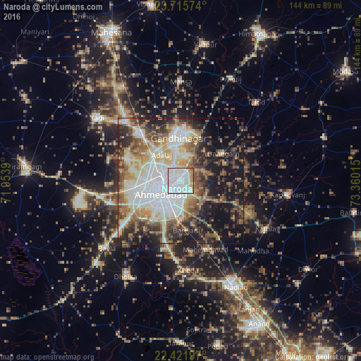
Analysis of Naroda night lights 2016
Square area 10x10 km:
 52.38%
90-99
30.36%80-89
6.55%70-79
5.56%60-69
4.37%50-59
0.79%40-49
0%30-39
0%20-29
0%10-19
0%0-9
0%Square area 50x50 km:
12.99%90-99
11.84%80-89
6.59%70-79
5.36%60-69
7.54%50-59
8.04%40-49
7.14%30-39
6.9%20-29
9.8%10-19
16.18%0-9
7.63%Clear (daylight) street map image can be seen on geolist.org.
Map coordinates:
23° 42' 56.7" North, 71° 57' 14" East
23° 4' 13.5" North, 72° 39' 25.3" East
22° 25' 19.1" North, 73° 21' 36.5" East
Some cities around Naroda sort by population:
• Ahmedabad
8.7 km =5.4 mi,  235°
235°
• Gandhinagar
16.5 km =10.3 mi,  9°
9°
• Dahegām
20.1 km =12.5 mi,  56°
56°
• Sānand
29.5 km =18.3 mi,  252°
252°
• Mahemdāvād
29.2 km =18.1 mi,  159°
159°
• Sarkhej
18.6 km =11.6 mi, 238°
• Chhala
29 km =18 mi,  24°
24°
• Adalaj
13 km =8.1 mi,  323°
323°
1261768 (p: 5,366)
Sources (retrieved 2019-11-25):
» Earth at Night: Flat Maps 2012, 2016