Adalaj night lights from space
Night Light of Adalaj (Gujarat) from space (India) Src. Average luminocity for 10x10km area is 87.7216% and for 50x50km: 52.7252%.
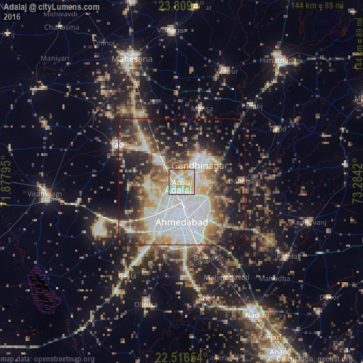
Analysis of Adalaj night lights 2016
Square area 10x10 km:
 13.83%
90-99
34.66%80-89
30.87%70-79
14.2%60-69
4.92%50-59
1.52%40-49
0%30-39
0%20-29
0%10-19
0%0-9
0%Square area 50x50 km:
13.08%90-99
11.71%80-89
6.72%70-79
5.63%60-69
7.24%50-59
6.91%40-49
6.76%30-39
6.29%20-29
9.79%10-19
13.94%0-9
11.93%Clear (daylight) street map image can be seen on geolist.org.
Map coordinates:
23° 48' 33.8" North, 71° 52' 40.6" East
23° 9' 52.3" North, 72° 34' 51.9" East
22° 30' 59.5" North, 73° 17' 3.1" East
Some cities around Adalaj sort by population:
• Ahmedabad
15.4 km =9.6 mi,  177°
177°
• Gandhinagar
12 km =7.5 mi,  60°
60°
• Dahegām
24.6 km =15.3 mi,  88°
88°
• Sānand
28 km =17.4 mi,  226°
226°
• Sarkhej
21.7 km =13.5 mi,  201°
201°
• Chhala
25.3 km =15.7 mi,  51°
51°
• Jhulasan
21.3 km =13.2 mi,  328°
328°
• Naroda
13 km =8.1 mi,  143°
143°
1279373 (p: 10,423)
Sources (retrieved 2019-11-25):
» Earth at Night: Flat Maps 2012, 2016