Chhala night lights from space
Night Light of Chhala (Gujarat) from space (India) Src. Average luminocity for 10x10km area is 10.1818% and for 50x50km: 24.4887%.
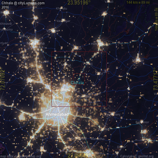
Analysis of Chhala night lights 2016
Square area 10x10 km:
 0%
0%90-99
0%80-89
0%70-79
0.76%60-69
1.7%50-59
1.52%40-49
2.46%30-39
6.06%20-29
3.03%10-19
7.58%0-9
76.89%Square area 50x50 km:
3.21%90-99
4.99%80-89
3.12%70-79
2.46%60-69
3.26%50-59
3.8%40-49
4.42%30-39
3.85%20-29
5.27%10-19
11.9%0-9
53.71%Clear (daylight) street map image can be seen on geolist.org.
Map coordinates:
23° 57' 7.1" North, 72° 4' 15.3" East
23° 18' 28" North, 72° 46' 26.5" East
22° 39' 37.8" North, 73° 28' 37.8" East
Some cities around Chhala sort by population:
• Ahmedabad
36.7 km =22.8 mi,  211°
211°
• Gandhinagar
13.7 km =8.5 mi,  222°
222°
• Dahegām
16.2 km =10.1 mi,  162°
162°
• Mānsa
17.7 km =11 mi,  317°
317°
• Vijāpur
28.4 km =17.6 mi,  354°
354°
• Adalaj
25.3 km =15.7 mi,  231°
231°
• Jhulasan
30.8 km =19.1 mi,  274°
274°
• Naroda
29 km =18 mi,  204°
204°
1274369 (p: 17,323)
Sources (retrieved 2019-11-25):
» Earth at Night: Flat Maps 2012, 2016