Muragācha night lights from space
Night Light of Muragācha (West Bengal) from space (India) Src. Average luminocity for 10x10km area is 16.2758% and for 50x50km: 14.3495%.
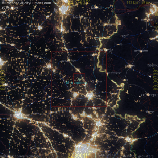
Analysis of Muragācha night lights 2016
Square area 10x10 km:
 0%
0%90-99
0%80-89
0%70-79
0.99%60-69
1.39%50-59
3.17%40-49
8.53%30-39
5.36%20-29
6.75%10-19
16.47%0-9
57.34%Square area 50x50 km:
0.46%90-99
1.49%80-89
0.71%70-79
1.1%60-69
1.65%50-59
2.61%40-49
3.77%30-39
3.76%20-29
7.48%10-19
13.65%0-9
63.32%Clear (daylight) street map image can be seen on geolist.org.
Map coordinates:
24° 10' 45.7" North, 87° 41' 28.1" East
23° 32' 10.7" North, 88° 23' 39.3" East
22° 53' 24.4" North, 89° 5' 50.6" East
Some cities around Muragācha sort by population:
• Shāntipur
32.4 km =20.1 mi,  172°
172°
• Krishnanagar
17.5 km =10.9 mi,  145°
145°
• Navadwīp
14.6 km =9.1 mi,  190°
190°
• Kātoya
29.3 km =18.2 mi,  294°
294°
• Rānāghāt
43.7 km =27.2 mi,  156°
156°
• Kālna
35.4 km =22 mi, 185°
• Bagulā
33.6 km =20.9 mi,  131°
131°
• Aistala
43.9 km =27.3 mi, 154°
1262452 (p: 10,324)
Sources (retrieved 2019-11-25):
» Earth at Night: Flat Maps 2012, 2016