Muhammadābād night lights from space
Night Light of Muhammadābād (Uttar Pradesh) from space (India) Src. Average luminocity for 10x10km area is 40.5625% and for 50x50km: 29.5802%.
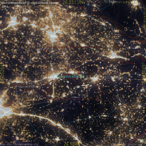
Analysis of Muhammadābād night lights 2016
Square area 10x10 km:
 2.84%
2.84%90-99
5.68%80-89
3.98%70-79
3.03%60-69
10.8%50-59
6.63%40-49
8.9%30-39
10.98%20-29
13.45%10-19
33.14%0-9
0.57%Square area 50x50 km:
1.88%90-99
2.37%80-89
2.25%70-79
3.1%60-69
4.07%50-59
5.45%40-49
7.64%30-39
9.88%20-29
13.94%10-19
33.19%0-9
16.24%Clear (daylight) street map image can be seen on geolist.org.
Map coordinates:
26° 15' 5" North, 83° 3' 9.5" East
25° 37' 8.7" North, 83° 45' 20.7" East
24° 59' 0.2" North, 84° 27' 32" East
Some cities around Muhammadābād sort by population:
• Mau
40.8 km =25.4 mi,  331°
331°
• Ghazīpur
17.6 km =10.9 mi,  256°
256°
• Buxar
23 km =14.3 mi,  102°
102°
• Dumraon
40.4 km =25.1 mi, 100°
• Kopāganj
48.4 km =30.1 mi,  336°
336°
• Zamānia
29.8 km =18.5 mi,  221°
221°
• Rasrā
28.3 km =17.6 mi,  20°
20°
• Sādāt
45.8 km =28.5 mi,  277°
277°
1262626 (p: 33,186)
Sources (retrieved 2019-11-25):
» Earth at Night: Flat Maps 2012, 2016