Sādāt night lights from space
Night Light of Sādāt (Uttar Pradesh) from space (India) Src. Average luminocity for 10x10km area is 21.5265% and for 50x50km: 26.9073%.
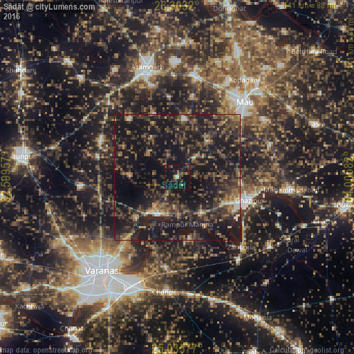
Analysis of Sādāt night lights 2016
Square area 10x10 km:
 0.76%
0.76%90-99
0.76%80-89
0%70-79
3.41%60-69
2.27%50-59
3.03%40-49
3.6%30-39
9.28%20-29
8.9%10-19
50.57%0-9
17.42%Square area 50x50 km:
0.57%90-99
1.06%80-89
1.25%70-79
2.53%60-69
3.73%50-59
5.97%40-49
8.56%30-39
10.39%20-29
13.74%10-19
37.7%0-9
14.48%Clear (daylight) street map image can be seen on geolist.org.
Map coordinates:
26° 18' 11.5" North, 82° 35' 58.5" East
25° 40' 16.2" North, 83° 18' 9.7" East
25° 2' 8.8" North, 84° 0' 21" East
Some cities around Sādāt sort by population:
• Mau
39.7 km =24.7 mi,  40°
40°
• Azamgarh
45.7 km =28.4 mi,  344°
344°
• Ghazīpur
30 km =18.6 mi,  109°
109°
• Zamānia
37.9 km =23.5 mi,  137°
137°
• Muhammadābād
41.1 km =25.5 mi,  11°
11°
• Saidpur
16.8 km =10.4 mi,  208°
208°
• Mehnagar
29.7 km =18.5 mi,  321°
321°
• Kirākat
38.9 km =24.2 mi,  264°
264°
1257887 (p: 11,211)
Sources (retrieved 2019-11-25):
» Earth at Night: Flat Maps 2012, 2016