Māchalpur night lights from space
Night Light of Māchalpur (Madhya Pradesh) from space (India) Src. Average luminocity for 10x10km area is 4.822% and for 50x50km: 5.5024%.
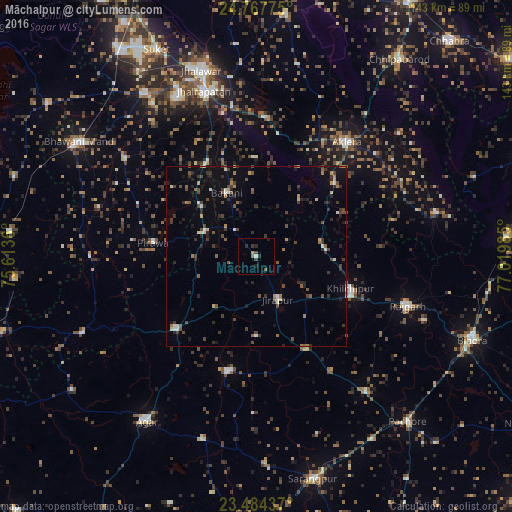
Analysis of Māchalpur night lights 2016
Square area 10x10 km:
 0.57%
0.57%90-99
0.19%80-89
0%70-79
0.76%60-69
0.76%50-59
0.76%40-49
0.95%30-39
1.7%20-29
1.89%10-19
1.52%0-9
90.91%Square area 50x50 km:
0.22%90-99
0.53%80-89
0.31%70-79
0.49%60-69
0.56%50-59
1.01%40-49
1.27%30-39
1.51%20-29
1.84%10-19
1.93%0-9
90.32%Clear (daylight) street map image can be seen on geolist.org.
Map coordinates:
24° 46' 3.9" North, 75° 36' 49" East
24° 7' 39.6" North, 76° 19' 0.2" East
23° 29' 3.7" North, 77° 1' 11.5" East
Some cities around Māchalpur sort by population:
• Jhālrapātan
48.3 km =30 mi,  342°
342°
• Rājgarh
44.3 km =27.5 mi,  107°
107°
• Aklera
40.6 km =25.2 mi,  38°
38°
• Khilchipur
28.3 km =17.6 mi, 110°
• Sunel
45.4 km =28.2 mi,  306°
306°
• Susner
30.7 km =19.1 mi,  229°
229°
• Pirāwa
29.5 km =18.3 mi,  275°
275°
• Bakāni
19.4 km =12.1 mi, 335°
1264653 (p: 8,556)
Sources (retrieved 2019-11-25):
» Earth at Night: Flat Maps 2012, 2016