Khilchipur night lights from space
Night Light of Khilchipur (Madhya Pradesh) from space (India) Src. Average luminocity for 10x10km area is 15.8144% and for 50x50km: 4.6839%.
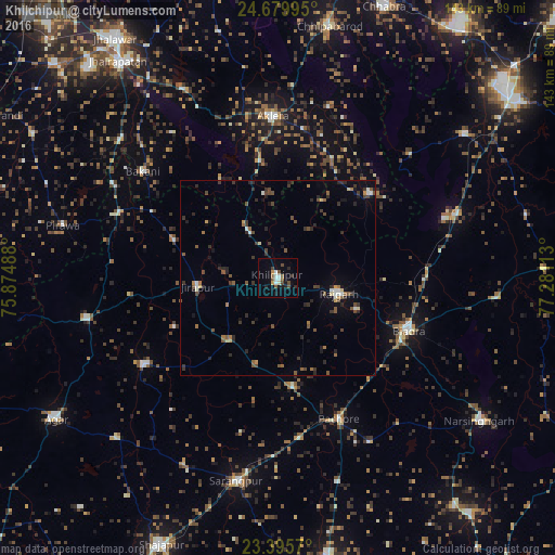
Analysis of Khilchipur night lights 2016
Square area 10x10 km:
 2.46%
2.46%90-99
2.27%80-89
0.57%70-79
1.52%60-69
1.52%50-59
2.46%40-49
4.17%30-39
0.95%20-29
2.46%10-19
6.82%0-9
74.81%Square area 50x50 km:
0.29%90-99
0.46%80-89
0.26%70-79
0.34%60-69
0.54%50-59
0.96%40-49
1.11%30-39
1.25%20-29
1.53%10-19
1.62%0-9
91.65%Clear (daylight) street map image can be seen on geolist.org.
Map coordinates:
24° 40' 47.8" North, 75° 52' 29.6" East
24° 2' 21.9" North, 76° 34' 40.8" East
23° 23' 44.5" North, 77° 16' 52.1" East
Some cities around Khilchipur sort by population:
• Biaora
36.3 km =22.6 mi,  111°
111°
• Rājgarh
16.1 km =10 mi,  102°
102°
• Aklera
41.5 km =25.8 mi,  358°
358°
• Susner
50.8 km =31.6 mi,  258°
258°
• Manohar Thāna
31.8 km =19.8 mi,  45°
45°
• Khujner
28.5 km =17.7 mi,  171°
171°
• Bakāni
44.1 km =27.4 mi,  308°
308°
• Māchalpur
28.3 km =17.6 mi,  290°
290°
1266731 (p: 16,411)
Sources (retrieved 2019-11-25):
» Earth at Night: Flat Maps 2012, 2016