Mankāpur night lights from space
Night Light of Mankāpur (Uttar Pradesh) from space (India) Src. Average luminocity for 10x10km area is 34.7877% and for 50x50km: 13.9106%.
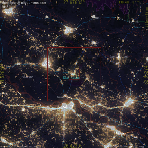
Analysis of Mankāpur night lights 2016
Square area 10x10 km:
 1.79%
1.79%90-99
2.98%80-89
3.57%70-79
6.15%60-69
3.97%50-59
9.92%40-49
5.75%30-39
11.51%20-29
10.71%10-19
36.9%0-9
6.75%Square area 50x50 km:
0.52%90-99
0.81%80-89
0.72%70-79
0.88%60-69
1.57%50-59
2.95%40-49
3.84%30-39
4.76%20-29
7.29%10-19
12.66%0-9
63.99%Clear (daylight) street map image can be seen on geolist.org.
Map coordinates:
27° 40' 34.8" North, 81° 31' 35.4" East
27° 3' 6.8" North, 82° 13' 46.6" East
26° 25' 26.2" North, 82° 55' 57.9" East
Some cities around Mankāpur sort by population:
• Fyzābād
31.7 km =19.7 mi,  194°
194°
• Gondā City
28.8 km =17.9 mi,  287°
287°
• Balrāmpur
42.2 km =26.2 mi,  354°
354°
• Ajodhya
28.2 km =17.5 mi, 185°
• Utraula
35.1 km =21.8 mi,  32°
32°
• Nawābganj
22.7 km =14.1 mi,  202°
202°
• Khargupur
43.2 km =26.8 mi,  326°
326°
• Haraiya
36.9 km =22.9 mi,  140°
140°
1263677 (p: 9,746)
Sources (retrieved 2019-11-25):
» Earth at Night: Flat Maps 2012, 2016