Nawābganj night lights from space
Night Light of Nawābganj (Uttar Pradesh) from space (India) Src. Average luminocity for 10x10km area is 20.3313% and for 50x50km: 25.4256%.
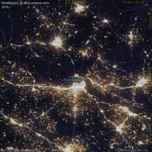
Analysis of Nawābganj night lights 2016
Square area 10x10 km:
 0.4%
0.4%90-99
1.98%80-89
0%70-79
0.79%60-69
4.96%50-59
2.78%40-49
2.58%30-39
5.56%20-29
19.84%10-19
22.62%0-9
38.49%Square area 50x50 km:
2.53%90-99
3.19%80-89
1.97%70-79
2.38%60-69
3.33%50-59
5.47%40-49
6.52%30-39
6.91%20-29
10.92%10-19
15.22%0-9
41.55%Clear (daylight) street map image can be seen on geolist.org.
Map coordinates:
27° 29' 22.1" North, 81° 26' 16.5" East
26° 51' 50.3" North, 82° 8' 27.7" East
26° 14' 6" North, 82° 50' 39" East
Some cities around Nawābganj sort by population:
• Fyzābād
9.9 km =6.2 mi,  174°
174°
• Gondā City
35.1 km =21.8 mi,  328°
328°
• Ajodhya
9.6 km =6 mi,  138°
138°
• Colonelganj
53.1 km =33 mi,  304°
304°
• Bīkāpur
29.9 km =18.6 mi,  181°
181°
• Goshāinganj
40.3 km =25 mi, 143°
• Mankāpur
22.7 km =14.1 mi,  22°
22°
• Haraiya
33 km =20.5 mi,  103°
103°
1261642 (p: 17,015)
Sources (retrieved 2019-11-25):
» Earth at Night: Flat Maps 2012, 2016