Khargupur night lights from space
Night Light of Khargupur (Uttar Pradesh) from space (India) Src. Average luminocity for 10x10km area is 9.4678% and for 50x50km: 11.2034%.
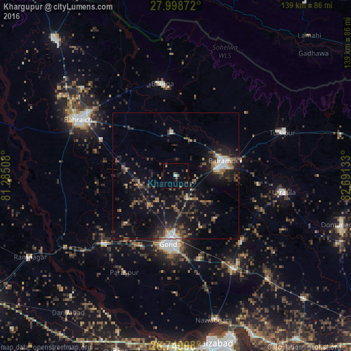
Analysis of Khargupur night lights 2016
Square area 10x10 km:
 0.95%
0.95%90-99
0.57%80-89
0%70-79
0.76%60-69
1.52%50-59
2.84%40-49
0.19%30-39
3.41%20-29
1.14%10-19
2.46%0-9
86.17%Square area 50x50 km:
1.02%90-99
0.92%80-89
0.68%70-79
0.79%60-69
1.42%50-59
1.78%40-49
2.36%30-39
3.1%20-29
4.71%10-19
9.52%0-9
73.7%Clear (daylight) street map image can be seen on geolist.org.
Map coordinates:
27° 59' 55.4" North, 81° 17' 6.3" East
27° 22' 34" North, 81° 59' 17.5" East
26° 44' 59.9" North, 82° 41' 28.8" East
Some cities around Khargupur sort by population:
• Gondā City
27.4 km =17 mi,  187°
187°
• Balrāmpur
20.4 km =12.7 mi,  73°
73°
• Utraula
43 km =26.7 mi,  98°
98°
• Colonelganj
39.3 km =24.4 mi,  226°
226°
• Bhinga
36.7 km =22.8 mi,  351°
351°
• Ikauna
17.3 km =10.7 mi, 353°
• Mankāpur
43.2 km =26.8 mi,  146°
146°
• Katra
15.2 km =9.4 mi,  14°
14°
1266926 (p: 9,576)
Sources (retrieved 2019-11-25):
» Earth at Night: Flat Maps 2012, 2016