Mādugula night lights from space
Night Light of Mādugula (Andhra Pradesh) from space (India) Src. Average luminocity for 10x10km area is 1.4719% and for 50x50km: 3.2277%.
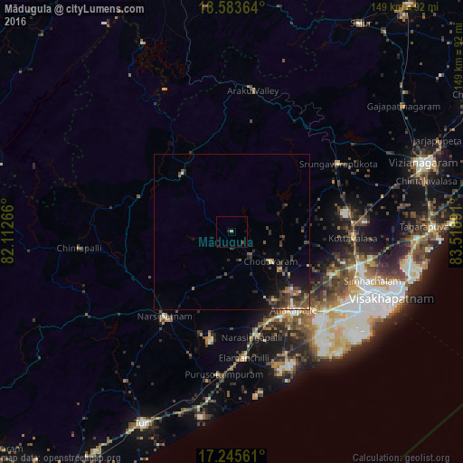
Analysis of Mādugula night lights 2016
Square area 10x10 km:
 0%
0%90-99
0%80-89
0%70-79
0.87%60-69
0%50-59
0%40-49
0.87%30-39
0%20-29
0.87%10-19
0.87%0-9
96.54%Square area 50x50 km:
0.05%90-99
0.27%80-89
0.29%70-79
0.24%60-69
0.52%50-59
0.62%40-49
1.01%30-39
1.16%20-29
1.25%10-19
2.06%0-9
92.54%Clear (daylight) street map image can be seen on geolist.org.
Map coordinates:
18° 35' 1.1" North, 82° 6' 45.6" East
17° 54' 57.2" North, 82° 48' 56.8" East
17° 14' 44.2" North, 83° 31' 8.1" East
Some cities around Mādugula sort by population:
• Visakhapatnam
48.5 km =30.1 mi,  122°
122°
• Gajuwaka
48.8 km =30.3 mi, 119°
• Anakāpalle
31.9 km =19.8 mi,  141°
141°
• Narsīpatnam
35.1 km =21.8 mi,  217°
217°
• Chodavaram
15.9 km =9.9 mi,  127°
127°
• Vepagunta
45 km =28 mi,  109°
109°
• Elamanchili
41 km =25.5 mi,  173°
173°
• Etikoppāka
47.1 km =29.3 mi,  190°
190°
1264525 (p: 14,741)
Sources (retrieved 2019-11-25):
» Earth at Night: Flat Maps 2012, 2016