Etikoppāka night lights from space
Night Light of Etikoppāka (Andhra Pradesh) from space (India) Src. Average luminocity for 10x10km area is 6.2293% and for 50x50km: 8.3994%.
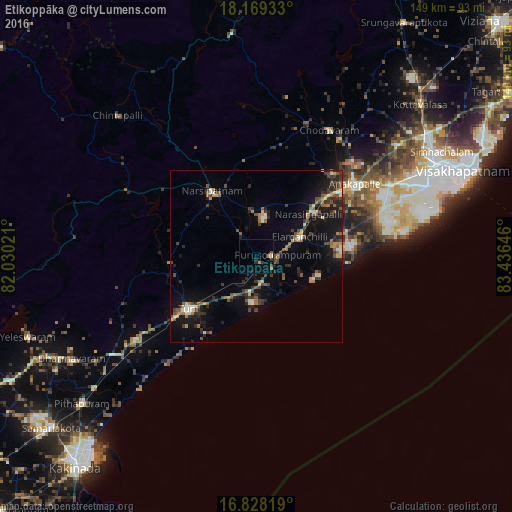
Analysis of Etikoppāka night lights 2016
Square area 10x10 km:
 0.21%
0.21%90-99
0.62%80-89
0%70-79
0.62%60-69
1.45%50-59
1.24%40-49
0.83%30-39
1.45%20-29
1.86%10-19
0.83%0-9
90.91%Square area 50x50 km:
0.28%90-99
0.93%80-89
0.61%70-79
0.84%60-69
1.26%50-59
1.6%40-49
1.71%30-39
1.97%20-29
2.47%10-19
6.96%0-9
81.37%Clear (daylight) street map image can be seen on geolist.org.
Map coordinates:
18° 10' 9.6" North, 82° 1' 48.8" East
17° 30' 0" North, 82° 43' 60" East
16° 49' 41.5" North, 83° 26' 11.3" East
Some cities around Etikoppāka sort by population:
• Visakhapatnam
53.5 km =33.2 mi,  68°
68°
• Gajuwaka
55.8 km =34.7 mi, 66°
• Anakāpalle
35.7 km =22.2 mi,  53°
53°
• Tuni
25.3 km =15.7 mi,  231°
231°
• Narsīpatnam
22.6 km =14 mi,  325°
325°
• Chodavaram
42.4 km =26.3 mi,  30°
30°
• Elamanchili
14.3 km =8.9 mi, 67°
• Mādugula
47.1 km =29.3 mi,  10°
10°
1271985 (p: 12,000)
Sources (retrieved 2019-11-25):
» Earth at Night: Flat Maps 2012, 2016