Gariāband night lights from space
Night Light of Gariāband (Chhattisgarh) from space (India) Src. Average luminocity for 10x10km area is 10.9053% and for 50x50km: 2.3112%.
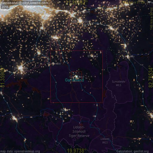
Analysis of Gariāband night lights 2016
Square area 10x10 km:
 0.76%
0.76%90-99
0.76%80-89
0.76%70-79
0.76%60-69
1.14%50-59
2.08%40-49
4.55%30-39
3.22%20-29
2.84%10-19
2.84%0-9
80.3%Square area 50x50 km:
0.04%90-99
0.09%80-89
0.06%70-79
0.07%60-69
0.21%50-59
0.51%40-49
0.96%30-39
1.15%20-29
1.01%10-19
0.56%0-9
95.35%Clear (daylight) street map image can be seen on geolist.org.
Map coordinates:
21° 17' 23.4" North, 81° 21' 32.7" East
20° 37' 59.6" North, 82° 3' 44" East
19° 58' 25.7" North, 82° 45' 55.2" East
Some cities around Gariāband sort by population:
• Dhamtari
54 km =33.6 mi,  278°
278°
• Mahāsamund
52.8 km =32.8 mi,  3°
3°
• Arang
63.4 km =39.4 mi,  351°
351°
• Kurud
41.6 km =25.8 mi,  301°
301°
• Pātan
70.7 km =43.9 mi,  308°
308°
• Bhatgaon
68.7 km =42.7 mi,  326°
326°
• Khamharia
42.9 km =26.7 mi,  27°
27°
• Narharpur
50.4 km =31.3 mi,  246°
246°
1271534 (p: 10,416)
Sources (retrieved 2019-11-25):
» Earth at Night: Flat Maps 2012, 2016