Mūlanūr night lights from space
Night Light of Mūlanūr (Tamil Nadu) from space (India) Src. Average luminocity for 10x10km area is 1.3595% and for 50x50km: 4.7178%.
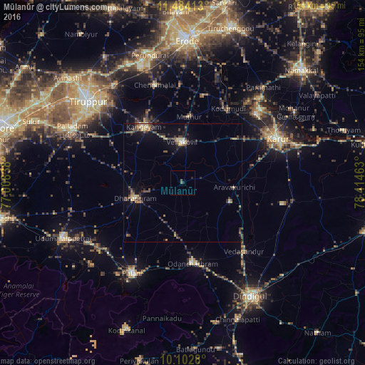
Analysis of Mūlanūr night lights 2016
Square area 10x10 km:
 0%
0%90-99
0%80-89
0%70-79
0%60-69
0%50-59
0.83%40-49
0.83%30-39
0%20-29
1.45%10-19
0.21%0-9
96.69%Square area 50x50 km:
0.02%90-99
0.4%80-89
0.7%70-79
0.54%60-69
0.54%50-59
0.83%40-49
1.32%30-39
1.13%20-29
1.36%10-19
3.11%0-9
90.05%Clear (daylight) street map image can be seen on geolist.org.
Map coordinates:
11° 29' 2.9" North, 77° 0' 30.2" East
10° 47' 39.3" North, 77° 42' 41.4" East
10° 6' 10.1" North, 78° 24' 52.7" East
Some cities around Mūlanūr sort by population:
• Dharapuram
20.5 km =12.7 mi,  252°
252°
• Kangayam
28.7 km =17.8 mi,  325°
325°
• Ayakudi
42.1 km =26.2 mi,  204°
204°
• Pallappatti
20.1 km =12.5 mi,  114°
114°
• Sivagiri
37.2 km =23.1 mi,  12°
12°
• Kodumudi
36.7 km =22.8 mi,  30°
30°
• Vedasandūr
39.2 km =24.4 mi,  138°
138°
• Kīranūr
31.8 km =19.8 mi,  225°
225°
1262567 (p: 12,264)
Sources (retrieved 2019-11-25):
» Earth at Night: Flat Maps 2012, 2016