Sārangarh night lights from space
Night Light of Sārangarh (Chhattisgarh) from space (India) Src. Average luminocity for 10x10km area is 27.1269% and for 50x50km: 9.7914%.
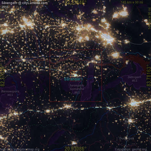
Analysis of Sārangarh night lights 2016
Square area 10x10 km:
 2.27%
2.27%90-99
2.27%80-89
4.55%70-79
2.46%60-69
4.55%50-59
5.11%40-49
6.44%30-39
3.22%20-29
5.49%10-19
30.11%0-9
33.52%Square area 50x50 km:
0.36%90-99
0.46%80-89
0.49%70-79
0.74%60-69
0.91%50-59
2.12%40-49
2.81%30-39
3.14%20-29
3.85%10-19
8.51%0-9
76.61%Clear (daylight) street map image can be seen on geolist.org.
Map coordinates:
22° 14' 18.5" North, 82° 22' 31.4" East
21° 35' 10.1" North, 83° 4' 42.6" East
20° 55' 51.1" North, 83° 46' 53.9" East
Some cities around Sārangarh sort by population:
• Raigarh
47.7 km =29.6 mi,  43°
43°
• Saktī
50.5 km =31.4 mi,  346°
346°
• Saraipali
31 km =19.3 mi,  193°
193°
• Kharsia
44.9 km =27.9 mi,  3°
3°
• Deori
50.1 km =31.1 mi,  252°
252°
• Basna
43 km =26.7 mi,  217°
217°
• Kharod
54.5 km =33.9 mi,  288°
288°
• Seorīnārāyan
52.3 km =32.5 mi, 286°
1257242 (p: 14,615)
Sources (retrieved 2019-11-25):
» Earth at Night: Flat Maps 2012, 2016