Seorīnārāyan night lights from space
Night Light of Seorīnārāyan (Chhattisgarh) from space (India) Src. Average luminocity for 10x10km area is 24.358% and for 50x50km: 11.5857%.
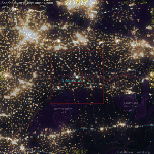
Analysis of Seorīnārāyan night lights 2016
Square area 10x10 km:
 1.52%
1.52%90-99
3.79%80-89
1.33%70-79
2.08%60-69
1.89%50-59
5.11%40-49
5.87%30-39
5.68%20-29
4.36%10-19
39.02%0-9
29.36%Square area 50x50 km:
0.22%90-99
0.59%80-89
0.6%70-79
0.85%60-69
1.32%50-59
2.47%40-49
3.23%30-39
3.41%20-29
4.06%10-19
8.37%0-9
74.88%Clear (daylight) street map image can be seen on geolist.org.
Map coordinates:
22° 22' 20.1" North, 81° 53' 25.2" East
21° 43' 14" North, 82° 35' 36.4" East
21° 3' 57.2" North, 83° 17' 47.7" East
Some cities around Seorīnārāyan sort by population:
• Chāmpa
35.4 km =22 mi,  8°
8°
• Jānjgīr
32.1 km =19.9 mi,  357°
357°
• Baloda Bāzār
45.3 km =28.1 mi,  260°
260°
• Saktī
50.9 km =31.6 mi,  48°
48°
• Akaltara
37.9 km =23.5 mi,  332°
332°
• Deori
30.2 km =18.8 mi,  175°
175°
• Baloda
47.9 km =29.8 mi,  346°
346°
• Kharod
3 km =1.9 mi, 330°
1256820 (p: 8,880)
Sources (retrieved 2019-11-25):
» Earth at Night: Flat Maps 2012, 2016