Parīchhatgarh night lights from space
Night Light of Parīchhatgarh (Uttar Pradesh) from space (India) Src. Average luminocity for 10x10km area is 30.3075% and for 50x50km: 30.9963%.
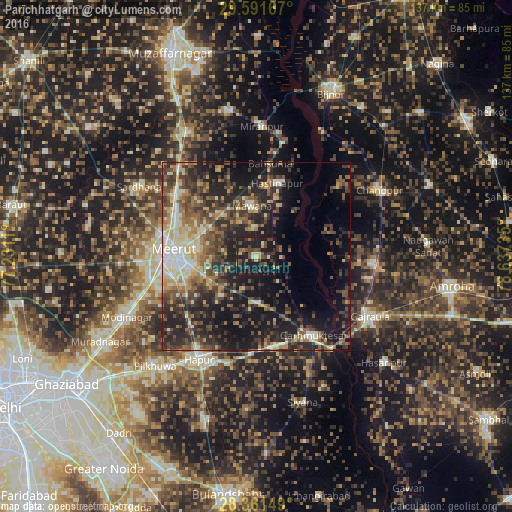
Analysis of Parīchhatgarh night lights 2016
Square area 10x10 km:
 0%
0%90-99
2.78%80-89
3.37%70-79
4.17%60-69
1.79%50-59
4.96%40-49
11.71%30-39
10.12%20-29
7.54%10-19
50.2%0-9
3.37%Square area 50x50 km:
2.13%90-99
4.65%80-89
4.12%70-79
3.53%60-69
4.09%50-59
5.86%40-49
7.83%30-39
7.87%20-29
11.03%10-19
20.04%0-9
28.87%Clear (daylight) street map image can be seen on geolist.org.
Map coordinates:
29° 35' 30" North, 77° 13' 52" East
28° 58' 42.3" North, 77° 56' 3.2" East
28° 21' 41.4" North, 78° 38' 14.5" East
Some cities around Parīchhatgarh sort by population:
• Meerut
22.2 km =13.8 mi,  270°
270°
• Mawāna
13.9 km =8.6 mi,  355°
355°
• Kithor
12.4 km =7.7 mi,  178°
178°
• Hastināpur
21.5 km =13.4 mi,  19°
19°
• Lāwar Khās
21.2 km =13.2 mi,  314°
314°
• Phalauda
25.4 km =15.8 mi,  336°
336°
• Kharkhauda
24.5 km =15.2 mi,  229°
229°
• Bahsūma
25 km =15.5 mi,  8°
8°
1260313 (p: 18,990)
Sources (retrieved 2019-11-25):
» Earth at Night: Flat Maps 2012, 2016