Kāpren night lights from space
Night Light of Kāpren (Rajasthan) from space (India) Src. Average luminocity for 10x10km area is 9.6905% and for 50x50km: 11.863%.
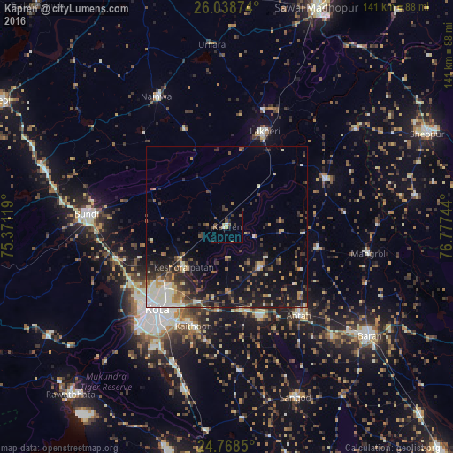
Analysis of Kāpren night lights 2016
Square area 10x10 km:
 0%
0%90-99
1.59%80-89
0.79%70-79
1.19%60-69
0%50-59
1.79%40-49
4.37%30-39
2.38%20-29
1.39%10-19
0.79%0-9
85.71%Square area 50x50 km:
1.11%90-99
2.29%80-89
0.83%70-79
1.42%60-69
1.28%50-59
1.45%40-49
2.18%30-39
2.87%20-29
3.16%10-19
8.82%0-9
74.6%Clear (daylight) street map image can be seen on geolist.org.
Map coordinates:
26° 2' 19.5" North, 75° 22' 16.3" East
25° 24' 19" North, 76° 4' 27.5" East
24° 46' 6.6" North, 76° 46' 38.8" East
Some cities around Kāpren sort by population:
• Kota
34.2 km =21.3 mi,  223°
223°
• Būndi
44 km =27.3 mi,  274°
274°
• Bārān
56 km =34.8 mi,  127°
127°
• Anta
36.3 km =22.6 mi,  141°
141°
• Lākheri
31.4 km =19.5 mi,  19°
19°
• Māngrol
44.5 km =27.7 mi,  100°
100°
• Keshorai Pātan
18.4 km =11.4 mi,  227°
227°
• Nainwa
46.5 km =28.9 mi,  331°
331°
1267923 (p: 19,671)
Sources (retrieved 2019-11-25):
» Earth at Night: Flat Maps 2012, 2016